Attēls:Gibraltar map-en-edit2.svg

Size of this PNG preview of this SVG file: 385 × 600 pikseļi. Citi izmēri: 154 × 240 pikseļi | 308 × 480 pikseļi | 493 × 768 pikseļi | 657 × 1 024 pikseļi | 1 314 × 2 048 pikseļi | 1 000 × 1 558 pikseļi.
Sākotnējais fails (SVG fails, definētais izmērs 1 000 × 1 558 pikseļi, faila izmērs: 1,46 MB)
| Šis fails ir no Vikikrātuves. Tā apraksts no attēla lapas Vikikrātuvē ir parādīts zemāk. Vikikrātuve ir brīvi licencēta failu krātuve. Tu vari tai palīdzēt. |
Kopsavilkums
|
This W3C-unspecified vector image was created with Inkscape .
| Camera location | | View this and other nearby images on: OpenStreetMap |
|---|
| Apraksts |
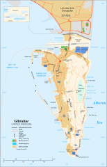
English: Map in English of Gibraltar
Français : Carte en anglais de Gibraltar |
| Datums | |
| Avots |
English: adapted from: Image:Gibraltar map-en.svg
Français : Création personnelle ;
|
| Autors | Original by Eric Gaba (Sting), label/legend edits by Jeff Dahl |
| Atļauja: (Šī faila izmantošana citur) |
Attribution and Share-Alike required |
| Citas versijas |
|


|
This SVG file contains embedded text that can be translated into your language, using any capable SVG editor, text editor or the SVG Translate tool. For more information see: About translating SVG files. |
Licence
Es, šī darba autortiesību īpašnieks, publicēju to saskaņā ar šīm licencēm:

|
Ir dota atļauja kopēt, izplatīt un/vai pārveidot šo dokumentu saskaņā ar GNU brīvās dokumentācijas licences, versijas 1.2 vai jebkuras vēlākas versijas, ko publiskojis Brīvās programmatūras fonds nosacījumiem; bez nemainīgajām sadaļā, priekšējā un aizmugurēja'vāka tekstiem. Licences kopija ir iekļauta sadaļā ar nosaukumu GNU brīvās dokumentācijas licence. |
This file is licensed under the Creative Commons Attribution-Share Alike 4.0 International, 3.0 Unported, 2.5 Generic, 2.0 Generic and 1.0 Generic license.
- Jūs varat brīvi:
- koplietot – kopēt, izplatīt un pārraidīt darbu
- remiksēt – pielāgot darbu
- Saskaņā ar šādiem nosacījumiem:
- atsaucoties – Tev ir jānorāda autors, saite uz licenci un to, vai veiktas kādas izmaiņas. To var darīt jebkādā saprātīgā veidā, bet ne tādā, kas norādītu, ka licencētājs atbalsta tevi vai veidu, kā tu izmanto šo darbu.
- nemainot licenci – Ja tu miksē, pārveido vai izmanto materiālu, tev savs devums jāpublicē ar to pašu vai saderīgu licenci kā oriģināls.
Jūs varat izvēlēties licenci pēc jūsu vēlmes.
Faila hronoloģija
Uzklikšķini uz datums/laiks kolonnā esošās saites, lai apskatītos, kā šis fails izskatījās tad.
| Datums/Laiks | Attēls | Izmēri | Dalībnieks | Komentārs | |
|---|---|---|---|---|---|
| tagadējais | 2017. gada 5. aprīlis, plkst. 19.36 | | 1 000 × 1 558 (1,46 MB) | RaviC | + University, Ferry terminal (& Route), Cathedral |
| 2007. gada 11. decembris, plkst. 21.52 |  | 1 000 × 1 558 (1,79 MB) | Jeff Dahl | resized 1200 down to 1000px wide, minor label fixes | |
| 2007. gada 10. decembris, plkst. 20.08 |  | 1 200 × 1 870 (1,78 MB) | Jeff Dahl | {{inkscape}} {{Location|36|08|00|N|5|21|00|W|type:city_scale:50000}} {{Information |Description=Map in English of Gibraltar |Source=adapted from: Image:Gibraltar map-en.svg <br/>Map created using screenshots of [[:en:Google Ea |
Faila lietojums
Šo failu izmanto šajās 7 lapās:
Globālais faila lietojums
Šīs Vikipēdijas izmanto šo failu:
- Izmantojums af.wikipedia.org
- Izmantojums ar.wikipedia.org
- Izmantojums av.wikipedia.org
- Izmantojums azb.wikipedia.org
- Izmantojums bg.wikipedia.org
- Izmantojums bn.wikipedia.org
- Izmantojums bs.wikipedia.org
- Izmantojums ceb.wikipedia.org
- Plantilya:Location map Gibraltar
- Signal Hill
- White Rock
- Sandy Bay
- Roca Blanca
- Ailsa Craig
- Passage Point
- El Peñón
- The Rock
- Middle Hill
- Gibraltar (pagklaro)
- Rock of Gibraltar
- Deadmans Beach
- Eastern Beach
- Western Beach
- Punta Pasaje
- Punta Europa
- La Roca
- Governor’s Beach
- Camp Bay
- Europa Point
- Gibraltar Bay
- Cerro de Enmedio
- Blackstrap Bay
- Caledonian Canal
- Great Europa Point
- Gibilterra
- White Rock (bato sa Gyibraltar)
- Western Beach (lapyahan sa Gyibraltar)
- Signal Hill (bungtod sa Gyibraltar)
- Sandy Bay North
- Sandy Bay (luuk)
- Saint Michael's Cave
- Saint Abb's Head
- North Gorge
- Middle Hill (bungtod sa Gyibraltar)
- Mediterranean Steps
- Martin's Cave
- Europa Point (punta sa Gyibraltar)
- The Lido
- Levant Cave
- H.M.S. Rooke
Skatīt šī faila pilno globālo izmantojumu.