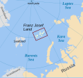
Attēls:Franz Josef Land location-en.svg

Size of this PNG preview of this SVG file: 507 × 470 pikseļi. Citi izmēri: 259 × 240 pikseļi | 518 × 480 pikseļi | 828 × 768 pikseļi | 1 105 × 1 024 pikseļi | 2 209 × 2 048 pikseļi.
Sākotnējais fails (SVG fails, definētais izmērs 507 × 470 pikseļi, faila izmērs: 57 KB)
Faila hronoloģija
Uzklikšķini uz datums/laiks kolonnā esošās saites, lai apskatītos, kā šis fails izskatījās tad.
| Datums/Laiks | Attēls | Izmēri | Dalībnieks | Komentārs | |
|---|---|---|---|---|---|
| tagadējais | 2017. gada 5. novembris, plkst. 08.41 |  | 507 × 470 (57 KB) | Mikhail Ryazanov | Laptev, not Laptov |
| 2010. gada 29. oktobris, plkst. 13.37 |  | 507 × 470 (57 KB) | Mysid | country labels | |
| 2010. gada 29. oktobris, plkst. 11.06 |  | 505 × 468 (112 KB) | Mysid | {{Information |Description={{en|1=Location of w:Franz Josef Land of Russia.}} |Source=Self-made in Inkscape; shoreline from File:Worldmap northern.svg (Natural Earth Data) and File:Franzjosef.PNG. |Author=Mysid |Date=2010-1 |
Faila lietojums
Šo failu neizmanto nevienā lapā.
Globālais faila lietojums
Šīs Vikipēdijas izmanto šo failu:
- Izmantojums avk.wikipedia.org
- Izmantojums el.wikipedia.org
- Izmantojums en.wikipedia.org
- Izmantojums eu.wikipedia.org
- Izmantojums fa.wikipedia.org
- Izmantojums hr.wikipedia.org
- Izmantojums is.wikipedia.org
- Izmantojums ja.wikipedia.org
- Izmantojums ko.wikipedia.org
- Izmantojums lt.wikipedia.org
- Izmantojums mk.wikipedia.org
- Izmantojums ml.wikipedia.org
- Izmantojums pl.wikipedia.org
- Izmantojums ro.wikipedia.org
- Izmantojums simple.wikipedia.org
- Izmantojums sl.wikipedia.org
- Izmantojums sv.wikipedia.org
- Izmantojums sw.wikipedia.org
- Izmantojums th.wikipedia.org
- Izmantojums tr.wikipedia.org
- Izmantojums uz.wikipedia.org
- Izmantojums vi.wikipedia.org
- Izmantojums war.wikipedia.org


