Attēls:Europe mediterranean 1190 cropped.jpg
Sākotnējais fails (796 × 753 pikseļi, faila izmērs: 257 KB, MIME tips: image/jpeg)
| Šis fails ir no Vikikrātuves. Tā apraksts no attēla lapas Vikikrātuvē ir parādīts zemāk. Vikikrātuve ir brīvi licencēta failu krātuve. Tu vari tai palīdzēt. |
Kopsavilkums
| Apraksts |
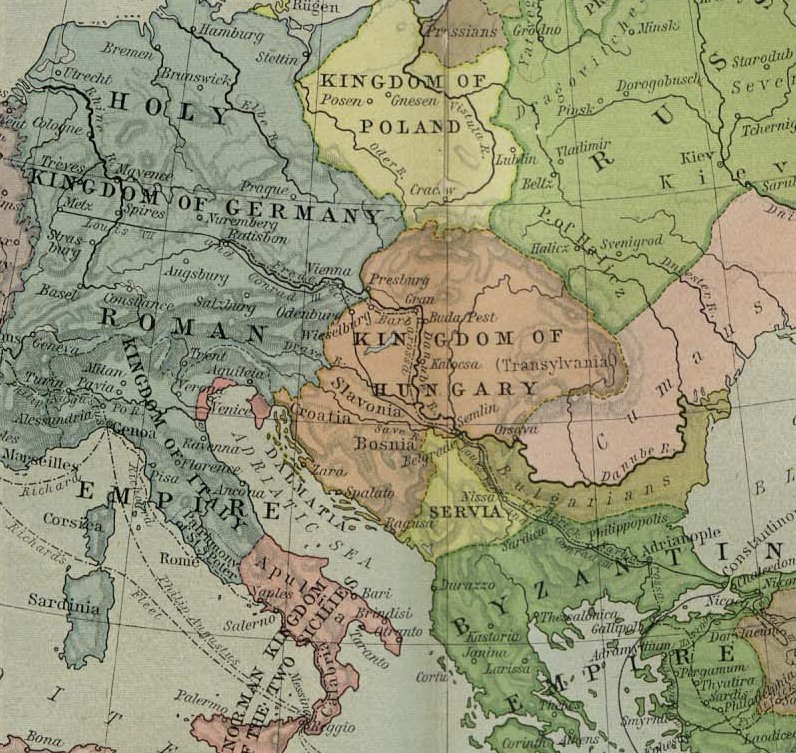
English: Map of Europe, ca. 1190 A.D. |
| Datums | 1923. gada - 1926. gada |
| Avots | Cropped from a map from the Historical Atlas by William Shepherd (1923–26), which is in the public domain in U.S. (http://www.lib.utexas.edu/maps/historical/shepherd/europe_mediterranean_1190.jpg) |
| Autors | William Shepherd |
| Citas versijas | Europe mediterranean 1190.jpg |
Licence
|
This work is in the public domain in its country of origin and other countries and areas where the copyright term is the author's life plus 70 years or fewer.
| |
| This file has been identified as being free of known restrictions under copyright law, including all related and neighboring rights. | |
Original upload log
- 2009-05-27 11:46 Hobartimus 796×753× (263194 bytes) {{Information |Description = Map of europe, cropped ca. 1190 A.D. |Source = Shrinked version of a map from the ''Historical Atlas'' by William Shepherd (1923-26), which is in the public domain in U.S. ( http://www.lib.utexas.edu/maps/historic
Faila hronoloģija
Uzklikšķini uz datums/laiks kolonnā esošās saites, lai apskatītos, kā šis fails izskatījās tad.
| Datums/Laiks | Attēls | Izmēri | Dalībnieks | Komentārs | |
|---|---|---|---|---|---|
| tagadējais | 2011. gada 14. augusts, plkst. 17.48 | | 796 × 753 (257 KB) | File Upload Bot (Magnus Manske) | {{BotMoveToCommons|en.wikipedia|year={{subst:CURRENTYEAR}}|month={{subst:CURRENTMONTHNAME}}|day={{subst:CURRENTDAY}}}} {{Information |Description={{en|Map of europe, cropped ca. 1190 A.D.}} |Source=Transferred from [http://en.wikipedia.org en.wikipedia]; |
Faila lietojums
Šo failu izmanto šajā 1 lapā:
Globālais faila lietojums
Šīs Vikipēdijas izmanto šo failu:
- Izmantojums ar.wikipedia.org
- Izmantojums ary.wikipedia.org
- Izmantojums azb.wikipedia.org
- Izmantojums bn.wikipedia.org
- Izmantojums br.wikipedia.org
- Izmantojums de.wikipedia.org
- Izmantojums el.wikipedia.org
- Izmantojums en.wikipedia.org
- Izmantojums es.wikipedia.org
- Izmantojums et.wikipedia.org
- Izmantojums fa.wikipedia.org
- Izmantojums fr.wikipedia.org
- Izmantojums he.wikipedia.org
- Izmantojums hu.wikipedia.org
- Izmantojums id.wikipedia.org
- Izmantojums id.wikibooks.org
- Izmantojums io.wikipedia.org
- Izmantojums it.wikipedia.org
Skatīt šī faila pilno globālo izmantojumu.