Attēls:Europe before Operation Barbarossa, 1941 (in German).png

Šī priekšskata izmērs: 575 × 599 pikseļi. Citi izmēri: 230 × 240 pikseļi | 461 × 480 pikseļi | 958 × 998 pikseļi.
Sākotnējais fails (958 × 998 pikseļi, faila izmērs: 142 KB, MIME tips: image/png)
| Šis fails ir no Vikikrātuves. Tā apraksts no attēla lapas Vikikrātuvē ir parādīts zemāk. Vikikrātuve ir brīvi licencēta failu krātuve. Tu vari tai palīdzēt. |
Kopsavilkums
| Apraksts |
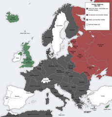
English: Map showing the Nazi, Finnish and Soviet-controlled borders of Europe by the end of May/beginning of June 1941, by the conclusion of the Nazi invasion of the Balkans and before Operation Barbarossa.
This PNG image, with captions in German, is derived from a frame from the GIF animation File:Second world war europe animation large de.gif at Wikimedia Commons. |
| Datums | 2010. gada 7. aprīlis (original upload date) |
| Avots | Transferred from en.wikipedia to Commons. |
| Autors |
The original uploader was MaGioZal at angļu Vikipēdija.. Later version(s) were uploaded by DIREKTOR at en.wikipedia. |
| Citas versijas |
|
.png)
.png?uselang=lv)
Licence

|
Ir dota atļauja kopēt, izplatīt un/vai pārveidot šo dokumentu saskaņā ar GNU brīvās dokumentācijas licences, versijas 1.2 vai jebkuras vēlākas versijas, ko publiskojis Brīvās programmatūras fonds nosacījumiem; bez nemainīgajām sadaļā, priekšējā un aizmugurēja'vāka tekstiem. Licences kopija ir iekļauta sadaļā ar nosaukumu GNU brīvās dokumentācijas licence. |
| Šis fails tiek izplatīts saskaņā ar licences Creative Commons Atsauce-Līdzīgi Noteikumi 3.0 Vispārējiem noteikumiem. | ||
| ||
| This licensing tag was added to this file as part of the GFDL licensing update. |
Original upload log
The original description page was here. All following user names refer to en.wikipedia.
- 2012-05-22 17:09 DIREKTOR 958×998× (200029 bytes) Colours
- 2010-04-07 01:43 MaGioZal 960×1000× (149500 bytes) Map showing the Nazi (darker blue) and Soviet-controlled (green) borders of Europe by the end of May/beginning of June [[1941]], after the [[Balkans Campaign|Nazi invasion of the Balkans]] and before [[Operation Barbarossa]]. This [[PNG image]], with cap
Faila hronoloģija
Uzklikšķini uz datums/laiks kolonnā esošās saites, lai apskatītos, kā šis fails izskatījās tad.
| Datums/Laiks | Attēls | Izmēri | Dalībnieks | Komentārs | |
|---|---|---|---|---|---|
| tagadējais | 2012. gada 7. septembris, plkst. 21.13 | | 958 × 998 (142 KB) | Illythr | Removed the "changes in the last frame" coloring, as there's only one frame here and the legend was misleading. |
| 2012. gada 16. augusts, plkst. 05.09 |  | 958 × 998 (195 KB) | OgreBot | (BOT): Reverting to most recent version before archival | |
| 2012. gada 16. augusts, plkst. 05.09 |  | 960 × 1 000 (146 KB) | OgreBot | (BOT): Uploading old version of file from en.wikipedia; originally uploaded on 2010-04-07 01:43:08 by MaGioZal | |
| 2012. gada 22. jūnijs, plkst. 23.04 |  | 958 × 998 (195 KB) | Friedlibend und tapfer | {{Information |Description={{en|Map showing the Nazi and Soviet-controlled borders of Europe by the end of May/beginning of June 1941, by the conclusion of the Nazi invasion of the Balkans and before [[:en:Operatio... |
Faila lietojums
Šo failu izmanto šajā 1 lapā:
Globālais faila lietojums
Šīs Vikipēdijas izmanto šo failu:
- Izmantojums af.wikipedia.org
- Izmantojums ar.wikipedia.org
- Izmantojums ast.wikipedia.org
- Izmantojums azb.wikipedia.org
- Izmantojums az.wikipedia.org
- Izmantojums bg.wikipedia.org
- Izmantojums bn.wikipedia.org
- Izmantojums br.wikipedia.org
- Izmantojums ca.wikipedia.org
- Izmantojums cs.wikipedia.org
- Izmantojums en.wikipedia.org
- Continuation War
- Molotov–Ribbentrop Pact
- Operation Barbarossa
- Eastern Front (World War II)
- Balkans campaign (World War II)
- Interim Peace
- User:Dead Mary/sandbox6
- User:Dead Mary/sandbox7
- Presidency of Franklin D. Roosevelt, third and fourth terms
- Foreign policy of the Franklin D. Roosevelt administration
- User:Falcaorib
- Izmantojums eo.wikipedia.org
- Izmantojums es.wikipedia.org
- Izmantojums fi.wikipedia.org
- Izmantojums hy.wikipedia.org
- Izmantojums lt.wikipedia.org
- Izmantojums nl.wikipedia.org
- Izmantojums pnb.wikipedia.org
- Izmantojums pt.wikipedia.org
- Izmantojums ru.wikipedia.org
- Izmantojums ta.wikipedia.org
- Izmantojums th.wikipedia.org
- Izmantojums ur.wikipedia.org
- Izmantojums zh.wikipedia.org
.png)