Attēls:Europe-Jersey.svg

Size of this PNG preview of this SVG file: 713 × 600 pikseļi. Citi izmēri: 285 × 240 pikseļi | 571 × 480 pikseļi | 913 × 768 pikseļi | 1 218 × 1 024 pikseļi | 2 435 × 2 048 pikseļi | 2 045 × 1 720 pikseļi.
Sākotnējais fails (SVG fails, definētais izmērs 2 045 × 1 720 pikseļi, faila izmērs: 7,73 MB)
| Šis fails ir no Vikikrātuves. Tā apraksts no attēla lapas Vikikrātuvē ir parādīts zemāk. Vikikrātuve ir brīvi licencēta failu krātuve. Tu vari tai palīdzēt. |
Kopsavilkums
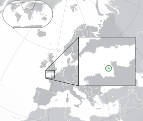
| Apraksts |
English: The Full Map of Jersey |
||
| Datums | |||
| Avots |
Own work based on: Europe-Northern Cyprus.svg and Europe-Serbia.svg |
||
| Autors | Chipmunkdavis | ||
| Citas versijas |
Derivative works of this file: |
||
| SVG veidošana |
|

Licence
Šis fails tiek izplatīts saskaņā ar licences Creative Commons Atsauce-Līdzīgi Noteikumi 3.0 Vispārējiem noteikumiem.
- Jūs varat brīvi:
- koplietot – kopēt, izplatīt un pārraidīt darbu
- remiksēt – pielāgot darbu
- Saskaņā ar šādiem nosacījumiem:
- atsaucoties – Tev ir jānorāda autors, saite uz licenci un to, vai veiktas kādas izmaiņas. To var darīt jebkādā saprātīgā veidā, bet ne tādā, kas norādītu, ka licencētājs atbalsta tevi vai veidu, kā tu izmanto šo darbu.
- nemainot licenci – Ja tu miksē, pārveido vai izmanto materiālu, tev savs devums jāpublicē ar to pašu vai saderīgu licenci kā oriģināls.
Original upload log
This image is a derivative work of the following images:
- Europe-Northern Cyprus.svg licensed with Cc-by-3.0
- 2011-02-20T17:16:12Z Chipmunkdavis 2045x1720 (2331880 Bytes) {{Information |Description={{en|1={{Europe-SVG-en|Northern Cyprus}}}} |Source=*[[:File:Europe-Serbia.svg|]] |Date=2011-02-20 17:14 (UTC) |Author=*[[:File:Europe-Serbia.svg|]]: {{click|image=TheEmirr-Logo.png|link=User:The Emi
- Jersey Map.svg licensed with PD-self
- 2009-04-02T01:46:41Z Ichwan Palongengi 626x433 (208689 Bytes) Remove the flaw...
- 2009-04-02T01:39:59Z Ichwan Palongengi 626x433 (207980 Bytes) {{Information |Description={{en|1=The Full Map of Jersey}} |Source=Own work by uploader |Author=[[User:Ichwan Palongengi|Ichwan Palongengi]] |Date=2009-03-01 |Permission= |other_versions= }} [[Category:Jersey]]
Uploaded with derivativeFX
Faila hronoloģija
Uzklikšķini uz datums/laiks kolonnā esošās saites, lai apskatītos, kā šis fails izskatījās tad.
| Datums/Laiks | Attēls | Izmēri | Dalībnieks | Komentārs | |
|---|---|---|---|---|---|
| tagadējais | 2017. gada 8. novembris, plkst. 04.57 | | 2 045 × 1 720 (7,73 MB) | Rob984 | Added circle like the original |
| 2017. gada 8. novembris, plkst. 03.35 |  | 2 045 × 1 720 (7,73 MB) | Rob984 | Modified to try to better locate the island both within the Channel and Europe (so multiple maps aren't needed) | |
| 2011. gada 21. februāris, plkst. 10.49 |  | 2 045 × 1 720 (2,28 MB) | Chipmunkdavis | {{Information |Description={{en|1={{Europe-SVG-en|Northern Cyprus}}}} {{en|1=The Full Map of Jersey}} |Source=*File:Europe-Northern_Cyprus.svg *File:Jersey_Map.svg |Date=2011-02-21 07:48 (UTC) |Author=*File:Europe-Northern_Cyprus.svg: *[ |
Faila lietojums
Šo failu izmanto šajā 1 lapā:
Globālais faila lietojums
Šīs Vikipēdijas izmanto šo failu:
- Izmantojums af.wikipedia.org
- Izmantojums ang.wikipedia.org
- Izmantojums ar.wikipedia.org
- Izmantojums arz.wikipedia.org
- Izmantojums ast.wikipedia.org
- Izmantojums azb.wikipedia.org
- Izmantojums az.wikipedia.org
- Izmantojums be-tarask.wikipedia.org
- Izmantojums be.wikipedia.org
- Izmantojums bh.wikipedia.org
- Izmantojums bn.wikipedia.org
- Izmantojums ca.wikipedia.org
- Izmantojums cdo.wikipedia.org
- Izmantojums chr.wikipedia.org
- Izmantojums cs.wikipedia.org
- Izmantojums da.wikipedia.org
- Izmantojums diq.wikipedia.org
- Izmantojums en.wikipedia.org
- Izmantojums en.wikivoyage.org
- Izmantojums es.wikipedia.org
- Izmantojums fa.wikipedia.org
- Izmantojums fi.wikipedia.org
- Izmantojums fr.wikipedia.org
- Izmantojums ga.wikipedia.org
- Izmantojums gl.wikipedia.org
- Izmantojums hak.wikipedia.org
- Izmantojums ha.wikipedia.org
- Izmantojums he.wikipedia.org
- Izmantojums he.wikivoyage.org
- Izmantojums hr.wikipedia.org
- Izmantojums hy.wikipedia.org
- Izmantojums ia.wikipedia.org
- Izmantojums incubator.wikimedia.org
- Izmantojums is.wikipedia.org
- Izmantojums it.wikipedia.org
Skatīt šī faila pilno globālo izmantojumu.