Attēls:Celts in Europe-fr.svg

Size of this PNG preview of this SVG file: 800 × 592 pikseļi. Citi izmēri: 320 × 237 pikseļi | 640 × 473 pikseļi | 1 024 × 757 pikseļi | 1 280 × 947 pikseļi | 2 560 × 1 893 pikseļi | 933 × 690 pikseļi.
Sākotnējais fails (SVG fails, definētais izmērs 933 × 690 pikseļi, faila izmērs: 165 KB)
| Šis fails ir no Vikikrātuves. Tā apraksts no attēla lapas Vikikrātuvē ir parādīts zemāk. Vikikrātuve ir brīvi licencēta failu krātuve. Tu vari tai palīdzēt. |
Kopsavilkums
| Apraksts |
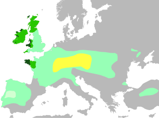
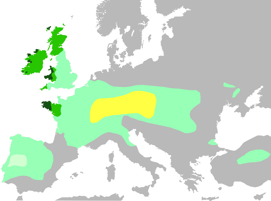
Français : Cette carte montre :
Noyau territorial Hallstatt, au VI siècle avant J.-C.
Expansion celtique maximale, en 275 avant J.-C.
Domaine lusitanien de l'Ibérie où la présence celtique est incertaine
Les six nations celtiques officielles aujourd'hui et qui pratiquaient le langage celtique au Moyen Âge (Bretagne, Pays de Galles, Cornouailles, Ile de Man, Irlande, Ecosse)
Zones où les langues celtiques restent largement parlées aujourd'hui English: Celts in Europe
the core Hallstatt territory, expansion before 500 BCE
maximum Celtic expansion by the 270s BCE
Lusitanian area of Iberia, "Celticity" uncertain
the boundaries of the six commonly-recognized 'Celtic nations', which remained Celtic speaking throughout the Middle Ages (viz. Brittany, Wales, Cornwall, Isle of Man, Ireland, Scotland)
areas that remain Celtic-speaking today Deutsch: Verbreitung keltischer Völker und Sprachen: Gebiet der Hallstatt-Kultur im 6. Jahrhundert v. Chr.
Größte keltische Ausdehnung, um 275 v. Chr.
Lusitania (keltische Besiedlung unsicher)
Die „sechs Keltischen Nationen“ in denen es bis in die Frühe Neuzeit eine signifikante Anzahl Sprecher keltischer Sprachen gab.
Das heutige Verbreitungsgebiet keltischer Sprachen |
| Datums | |
| Avots | |
| Autors | QuartierLatin1968, The Ogre, Dbachmann, Superwikifan; derivative work Augusta 89 |
| Citas versijas |
|

Licence
Es, šī darba autortiesību īpašnieks, publicēju to saskaņā ar šo licenci:
Šis fails tiek izplatīts saskaņā ar licences Creative Commons Atsauce-Līdzīgi Noteikumi 3.0 Vispārējiem noteikumiem.
- Jūs varat brīvi:
- koplietot – kopēt, izplatīt un pārraidīt darbu
- remiksēt – pielāgot darbu
- Saskaņā ar šādiem nosacījumiem:
- atsaucoties – Tev ir jānorāda autors, saite uz licenci un to, vai veiktas kādas izmaiņas. To var darīt jebkādā saprātīgā veidā, bet ne tādā, kas norādītu, ka licencētājs atbalsta tevi vai veidu, kā tu izmanto šo darbu.
- nemainot licenci – Ja tu miksē, pārveido vai izmanto materiālu, tev savs devums jāpublicē ar to pašu vai saderīgu licenci kā oriģināls.
Faila hronoloģija
Uzklikšķini uz datums/laiks kolonnā esošās saites, lai apskatītos, kā šis fails izskatījās tad.
| Datums/Laiks | Attēls | Izmēri | Dalībnieks | Komentārs | |
|---|---|---|---|---|---|
| tagadējais | 2016. gada 4. novembris, plkst. 21.35 | | 933 × 690 (165 KB) | Rob984 | Adjusted colour of sea and land to conform to widely used grey-white style, which I think looks better. Adds focus on the colour part of the map. |
| 2014. gada 3. jūlijs, plkst. 19.04 |  | 933 × 695 (274 KB) | Kopiersperre | same colours like in File:Celts in Europe.png | |
| 2014. gada 14. jūnijs, plkst. 15.04 |  | 933 × 695 (274 KB) | Augusta 89 | User created page with UploadWizard |
Faila lietojums
Šo failu izmanto šajā 1 lapā:
Globālais faila lietojums
Šīs Vikipēdijas izmanto šo failu:
- Izmantojums arz.wikipedia.org
- Izmantojums ast.wikipedia.org
- Izmantojums ca.wikipedia.org
- Izmantojums de.wikipedia.org
- Izmantojums de.wikivoyage.org
- Izmantojums en.wikipedia.org
- Izmantojums es.wikipedia.org
- Izmantojums eu.wikipedia.org
- Izmantojums fr.wikipedia.org
- Izmantojums fr.wikibooks.org
- Izmantojums ga.wikipedia.org
- Izmantojums gl.wikipedia.org
- Izmantojums hu.wikipedia.org
- Izmantojums pcd.wikipedia.org
- Izmantojums pt.wikipedia.org
- Izmantojums rm.wikipedia.org
- Izmantojums vec.wikipedia.org
- Izmantojums www.wikidata.org
- Izmantojums zh.wikipedia.org