Attēls:Bosporan Kingdom growth map-fr.svg

Size of this PNG preview of this SVG file: 675 × 575 pikseļi. Citi izmēri: 282 × 240 pikseļi | 564 × 480 pikseļi | 902 × 768 pikseļi | 1 202 × 1 024 pikseļi | 2 404 × 2 048 pikseļi.
Sākotnējais fails (SVG fails, definētais izmērs 675 × 575 pikseļi, faila izmērs: 1,13 MB)
| Šis fails ir no Vikikrātuves. Tā apraksts no attēla lapas Vikikrātuvē ir parādīts zemāk. Vikikrātuve ir brīvi licencēta failu krātuve. Tu vari tai palīdzēt. |
Kopsavilkums
| Apraksts |
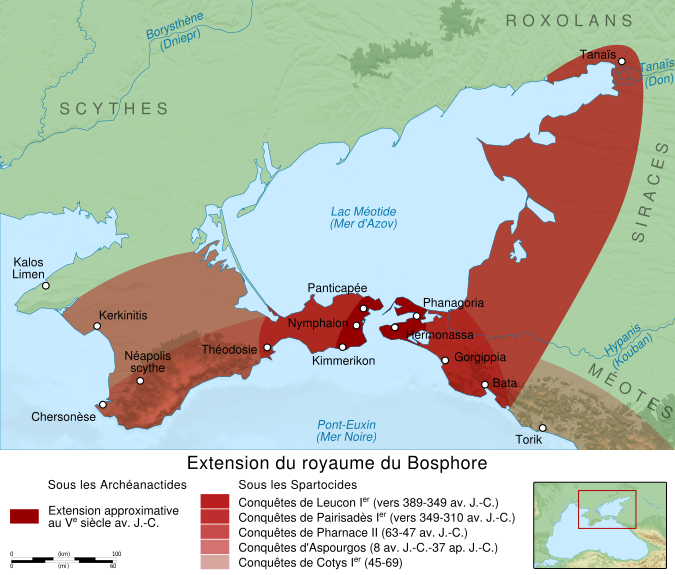
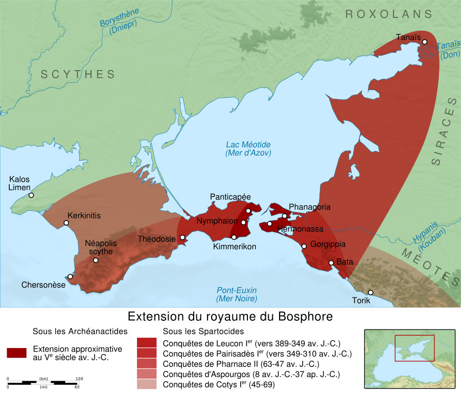
English: Map showing the growth of Bosporan Kingdom under the Spartocids dynasty. Français : Carte montrant l'extension du Royaume du Bosphore sous la dynastie des Spartocides. |
||
| Datums | (UTC) | ||
| Avots |
Paša darbs. Source:
|
||
| Autors | Sémhur (talk) | ||
| Citas versijas |
[]
| ||
| Atsauce (required by the license) | © Sémhur / Wikimedia Commons / | ||
| SVG | W3C-validity not checked.
|
||
| Graphic Lab |


| Object location | | View this and other nearby images on: OpenStreetMap |
|---|
Licence
Es, šī darba autortiesību īpašnieks, publicēju to saskaņā ar šīm licencēm:
| Copyleft: This work of art is free; you can redistribute it and/or modify it according to terms of the Free Art License. You will find a specimen of this license on the Copyleft Attitude site as well as on other sites. |
This file is licensed under the Creative Commons Attribution-Share Alike 4.0 International, 3.0 Unported, 2.5 Generic, 2.0 Generic and 1.0 Generic license.
- Jūs varat brīvi:
- koplietot – kopēt, izplatīt un pārraidīt darbu
- remiksēt – pielāgot darbu
- Saskaņā ar šādiem nosacījumiem:
- atsaucoties – Tev ir jānorāda autors, saite uz licenci un to, vai veiktas kādas izmaiņas. To var darīt jebkādā saprātīgā veidā, bet ne tādā, kas norādītu, ka licencētājs atbalsta tevi vai veidu, kā tu izmanto šo darbu.
- nemainot licenci – Ja tu miksē, pārveido vai izmanto materiālu, tev savs devums jāpublicē ar to pašu vai saderīgu licenci kā oriģināls.
Jūs varat izvēlēties licenci pēc jūsu vēlmes.
Faila hronoloģija
Uzklikšķini uz datums/laiks kolonnā esošās saites, lai apskatītos, kā šis fails izskatījās tad.
| Datums/Laiks | Attēls | Izmēri | Dalībnieks | Komentārs | |
|---|---|---|---|---|---|
| tagadējais | 2012. gada 12. februāris, plkst. 21.12 | | 675 × 575 (1,13 MB) | Sémhur | adding one colour in legend |
| 2012. gada 11. februāris, plkst. 21.31 |  | 675 × 575 (1,16 MB) | Sémhur | text to path (but adding a layer with all editable texts) | |
| 2012. gada 11. februāris, plkst. 21.13 |  | 675 × 575 (733 KB) | Sémhur | == {{int:filedesc}} == {{Information |Description={{Multilingual description |en= Map showing the growth of en:Bosporan Kingdom under the Spartocids dynasty. |fr= Carte montrant l'extension du fr:Royaume du Bosphore sous la dynastie des Sparto |
Faila lietojums
Šo failu izmanto šajā 1 lapā:
Globālais faila lietojums
Šīs Vikipēdijas izmanto šo failu:
- Izmantojums ar.wikipedia.org
- Izmantojums az.wikipedia.org
- Izmantojums bg.wikipedia.org
- Izmantojums ca.wikipedia.org
- Izmantojums cs.wikipedia.org
- Izmantojums de.wikipedia.org
- Izmantojums el.wikipedia.org
- Izmantojums en.wikipedia.org
- Izmantojums eo.wikipedia.org
- Izmantojums et.wikipedia.org
- Izmantojums eu.wikipedia.org
- Izmantojums fr.wikipedia.org
- Histoire de l'Ukraine
- Tauride
- Royaume du Bosphore
- Leucon Ier
- Pharnace II
- Aspourgos du Bosphore
- Pairisadès Ier
- Cotys Ier du Bosphore
- Wikipédia:Atelier graphique/Cartes/Archives/février 2012
- Julius Aquila
- Utilisateur:Leonard Fibonacci/Aristobule de Chalcis et sa mère Mariamne
- Utilisateur:Leonard Fibonacci/Aquila - Clément - Pont - Cherson
- Utilisateur:Leonard Fibonacci/Caïus Julius Aquila
- Izmantojums he.wikipedia.org
- Izmantojums hr.wikipedia.org
- Izmantojums it.wikipedia.org
- Izmantojums ko.wikipedia.org
- Izmantojums la.wikipedia.org
- Izmantojums nl.wikipedia.org
- Izmantojums no.wikipedia.org
- Izmantojums ro.wikipedia.org
- Izmantojums ru.wikipedia.org
- Izmantojums sk.wikipedia.org
- Izmantojums sv.wikipedia.org
- Izmantojums www.wikidata.org
- Izmantojums zh.wikipedia.org