Attēls:Aztec Empire 1519 map-fr.svg

Size of this PNG preview of this SVG file: 778 × 599 pikseļi. Citi izmēri: 312 × 240 pikseļi | 623 × 480 pikseļi | 997 × 768 pikseļi | 1 280 × 986 pikseļi | 2 560 × 1 972 pikseļi | 1 898 × 1 462 pikseļi.
Sākotnējais fails (SVG fails, definētais izmērs 1 898 × 1 462 pikseļi, faila izmērs: 303 KB)
| Šis fails ir no Vikikrātuves. Tā apraksts no attēla lapas Vikikrātuvē ir parādīts zemāk. Vikikrātuve ir brīvi licencēta failu krātuve. Tu vari tai palīdzēt. |
Kopsavilkums
| Apraksts |
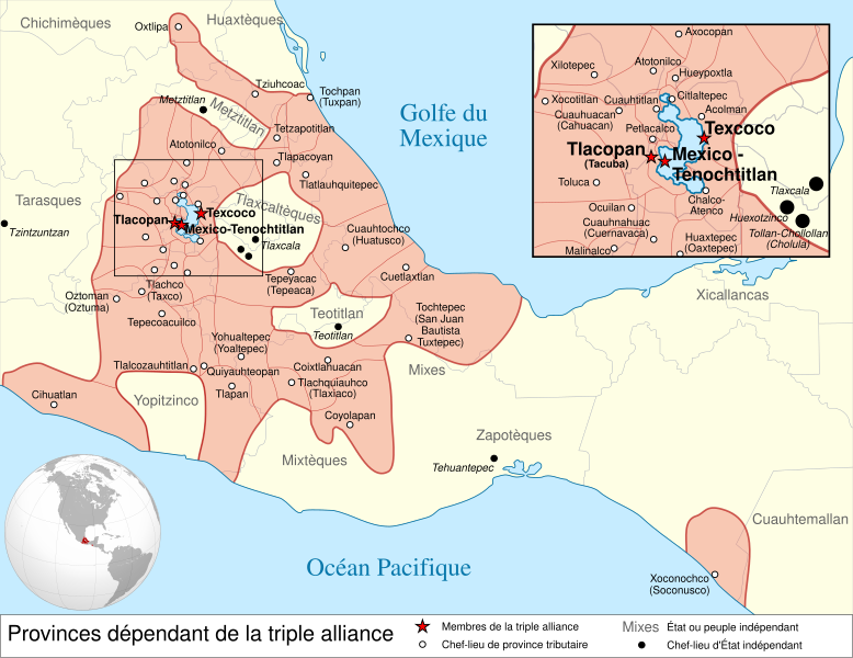
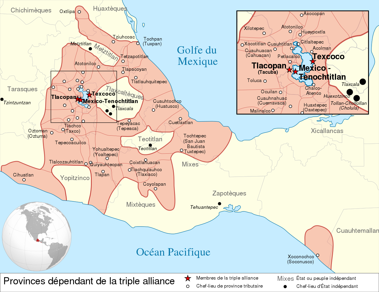
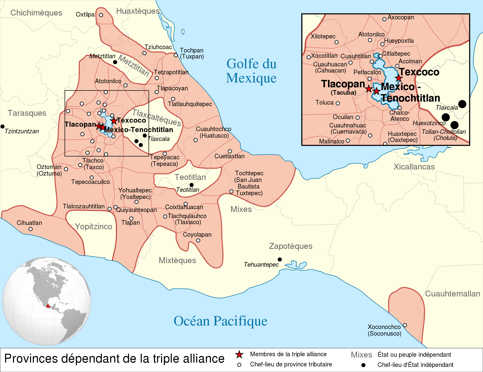
Español: Provincias tributarias de la Triple Alianza encabezada por Tenochtitlan antes de la llegada de los españoles en 1519.
English: Map of the Aztec Empire lead by Tenochtitlan circa 1519, before the arrival of the Spanish.
Français : Étendue de l'empire Aztèque soumis à la Triple Alliance, dirigée par Tenochtitlan, à l'arrivée des Espagnols en 1519. |
| Datums | (UTC) |
| Avots |
|
| Autors | |
| Citas versijas |
[] Detailed maps
Simple maps
|


.svg)
.svg)
.svg)
| Camera location | | View this and other nearby images on: OpenStreetMap |
|---|

|
This SVG file contains embedded text that can be translated into your language, using any capable SVG editor, text editor or the SVG Translate tool. For more information see: About translating SVG files. |
This W3C-unspecified vector image was created with Inkscape .
Licence
Šis fails tiek izplatīts saskaņā ar licences Creative Commons Atsauce-Līdzīgi Noteikumi 3.0 Vispārējiem noteikumiem.
- Jūs varat brīvi:
- koplietot – kopēt, izplatīt un pārraidīt darbu
- remiksēt – pielāgot darbu
- Saskaņā ar šādiem nosacījumiem:
- atsaucoties – Tev ir jānorāda autors, saite uz licenci un to, vai veiktas kādas izmaiņas. To var darīt jebkādā saprātīgā veidā, bet ne tādā, kas norādītu, ka licencētājs atbalsta tevi vai veidu, kā tu izmanto šo darbu.
- nemainot licenci – Ja tu miksē, pārveido vai izmanto materiālu, tev savs devums jāpublicē ar to pašu vai saderīgu licenci kā oriģināls.
Original upload log
This image is a derivative work of the following images:
- File:Provincias_tributarias_de_la_Triple_Alianza_(s._XVI).svg licensed with Cc-by-sa-3.0-migrated, FAL, GFDL
- 2008-12-13T03:29:16Z Yavidaxiu 949x731 (878329 Bytes) {{Information |Description={{es|1=Provincias tributarias de la Triple Alianza encabezada por Tenochtitlan antes de la llegada de los españoles. Fuente: ''Atlas del México prehispánico'', edición especial de ''Arqueología
- File:Aztec_Empire_(orthographic_projection).svg licensed with Cc-by-sa-3.0, GFDL
- 2010-02-11T12:23:41Z Sémhur 550x550 (104628 Bytes) Update with data from a sourced map.
- 2010-01-10T20:34:52Z Keepscases 550x550 (284361 Bytes) {{Information |Description={{en|1=Aztec Empire (orthographic projection)}} |Source={{own}} |Author=[[User:Keepscases|Keepscases]] |Date= |Permission= |other_versions= }} [[Category:SVG - Orthographic projections]]
Uploaded with derivativeFX
Faila hronoloģija
Uzklikšķini uz datums/laiks kolonnā esošās saites, lai apskatītos, kā šis fails izskatījās tad.
| Datums/Laiks | Attēls | Izmēri | Dalībnieks | Komentārs | |
|---|---|---|---|---|---|
| tagadējais | 2010. gada 23. marts, plkst. 18.01 | | 1 898 × 1 462 (303 KB) | El Comandante | État tarasque->Tarasques + Royaumes mixtèques->Mixtèques + Correction du positionnement de 2 textes |
| 2010. gada 7. marts, plkst. 20.58 |  | 1 898 × 1 462 (303 KB) | El Comandante | More readable fonts | |
| 2010. gada 25. februāris, plkst. 21.06 |  | 1 898 × 1 462 (306 KB) | Sémhur | Font : Nimbus Sans L | |
| 2010. gada 24. februāris, plkst. 20.29 |  | 949 × 731 (305 KB) | Sémhur | 2 - Encart de la région centrale | |
| 2010. gada 11. februāris, plkst. 15.55 |  | 949 × 731 (262 KB) | Sémhur | == {{int:filedesc}} == {{Information |Description={{es|1=Provincias tributarias de la Triple Alianza encabezada por Tenochtitlan antes de la llegada de los españoles en 1519.}} {{en|1=Map of the [[:en:Aztec Empire[Aztec Empire]] lead by Tenochtitlan circ |
Faila lietojums
Šo failu izmanto šajā 1 lapā:
Globālais faila lietojums
Šīs Vikipēdijas izmanto šo failu:
- Izmantojums af.wikipedia.org
- Izmantojums ar.wikipedia.org
- Izmantojums azb.wikipedia.org
- Izmantojums br.wikipedia.org
- Izmantojums el.wikipedia.org
- Izmantojums en.wikipedia.org
- Aztecs
- List of conflicts in North America
- Aztec Empire
- Wikipedia:WikiProject Aztec/Backup 2006-07-17
- Tlaxcala (Nahua state)
- Aztec architecture
- User:Maunus/sandbox
- Template:Aztec
- List of conflicts in Mexico
- User:Bobo.03/sandbox
- User:Tisquesusa/sandbox9
- Xihuitl Temoc
- User:SomeGuyWhoRandomlyEdits/List of conflicts in Mexico
- Talk:Aztec Empire/Archive 1
- Izmantojums en.wikibooks.org
- Izmantojums fi.wikipedia.org
- Izmantojums fr.wikipedia.org
- Izmantojums hy.wikipedia.org
- Izmantojums id.wikipedia.org
- Izmantojums id.wikibooks.org
- Izmantojums it.wikipedia.org
Skatīt šī faila pilno globālo izmantojumu.