Attēls:Aerial-View-Minamitori-Island-1987.jpg

Šī priekšskata izmērs: 800 × 507 pikseļi. Citi izmēri: 320 × 203 pikseļi | 640 × 405 pikseļi | 1 024 × 649 pikseļi | 1 280 × 811 pikseļi | 2 824 × 1 789 pikseļi.
Sākotnējais fails (2 824 × 1 789 pikseļi, faila izmērs: 1,09 MB, MIME tips: image/jpeg)
| Šis fails ir no Vikikrātuves. Tā apraksts no attēla lapas Vikikrātuvē ir parādīts zemāk. Vikikrātuve ir brīvi licencēta failu krātuve. Tu vari tai palīdzēt. |
Kopsavilkums
| Apraksts |
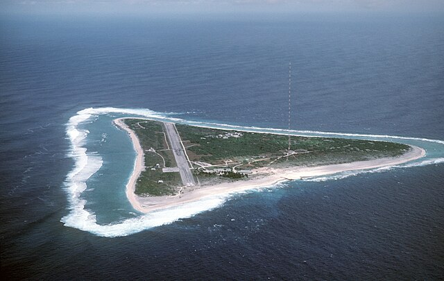
English: Aerial view of Minamitori Island (Minami-Torishima), Japan. There is a runway which supported the US Coast Guard station located there prior to 1993. Minamitori Island is the easternmost island of the Japanese archipelago.
Deutsch: Luftaufnahme der Minamitori Insel (Minami-Torishima), Japan.
日本語: 南鳥島の空中写真。 |
|||
| Datums | ||||
| Avots |
|
|||
| Autors | Chief Master Sergeant Don Sutherland, U.S. Air Force |
Licence
This image is a work of a U.S. military or Department of Defense employee, taken or made as part of that person's official duties. As a work of the U.S. federal government, the image is in the public domain in the United States.
|
 |
Faila hronoloģija
Uzklikšķini uz datums/laiks kolonnā esošās saites, lai apskatītos, kā šis fails izskatījās tad.
| Datums/Laiks | Attēls | Izmēri | Dalībnieks | Komentārs | |
|---|---|---|---|---|---|
| tagadējais | 2007. gada 18. janvāris, plkst. 04.38 | | 2 824 × 1 789 (1,09 MB) | Balcer~commonswiki | ID: DFST8708298 Service Depicted: Coalition or Allied Forces Aerial view of Marcus Island and the runway which supports the US Coast Guard station located there. Marcus Island is the southernmost island in the Japanese chain. Camera Operator: CMSGT |
Faila lietojums
Šo failu izmanto šajā 1 lapā:
Globālais faila lietojums
Šīs Vikipēdijas izmanto šo failu:
- Izmantojums ar.wikipedia.org
- Izmantojums ast.wikipedia.org
- Izmantojums az.wikipedia.org
- Izmantojums be.wikipedia.org
- Izmantojums ca.wikipedia.org
- Izmantojums ceb.wikipedia.org
- Izmantojums cs.wikipedia.org
- Izmantojums de.wikipedia.org
- Izmantojums el.wikipedia.org
- Izmantojums en.wikipedia.org
- Izmantojums es.wikipedia.org
- Izmantojums et.wikipedia.org
- Izmantojums eu.wikipedia.org
- Izmantojums fa.wikipedia.org
- Izmantojums fi.wikipedia.org
- Izmantojums frr.wikipedia.org
- Izmantojums fr.wikipedia.org
- Izmantojums fr.wiktionary.org
- Izmantojums gl.wikipedia.org
- Izmantojums hy.wikipedia.org
- Izmantojums it.wikipedia.org
- Izmantojums ja.wikipedia.org
Skatīt šī faila pilno globālo izmantojumu.