Attēls:Adıyaman districts.png
Sākotnējais fails (1 056 × 816 pikseļi, faila izmērs: 20 KB, MIME tips: image/png)
| Šis fails ir no Vikikrātuves. Tā apraksts no attēla lapas Vikikrātuvē ir parādīts zemāk. Vikikrātuve ir brīvi licencēta failu krātuve. Tu vari tai palīdzēt. |

|
This map has been uploaded by Electionworld from en.wikipedia.org to enable the |
Kopsavilkums
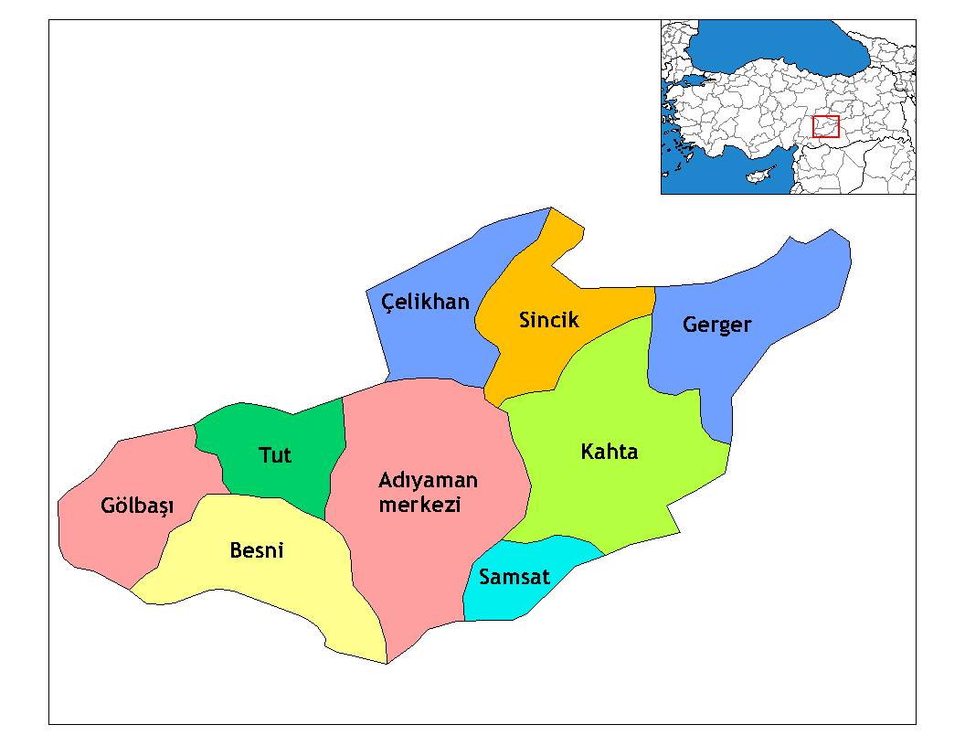
Map of the districts of Adıyaman province in Turkey. Created by Rarelibra 22:15, 13 November 2006 (UTC) for public domain use, using MapInfo Professional v8.5 and various mapping resources. Edited by One Homo Sapiens Corrected text where İ,Ş,ı,ğ,or ş occurs in name. Source: [statoids-com]. Increased font size and enhanced color differences among adjacent districts.

|
This locator map image could be re-created using vector graphics as an SVG file. This has several advantages; see Commons:Media for cleanup for more information. If an SVG form of this image is available, please upload it and afterwards replace this template with
{{vector version available|new image name}}.
It is recommended to name the SVG file “Adıyaman districts.svg”—then the template Vector version available (or Vva) does not need the new image name parameter. |
Licence
| This work has been released into the public domain by its author, Rarelibra. This applies worldwide. In some countries this may not be legally possible; if so: |
Renamed by Denizz
Faila hronoloģija
Uzklikšķini uz datums/laiks kolonnā esošās saites, lai apskatītos, kā šis fails izskatījās tad.
| Datums/Laiks | Attēls | Izmēri | Dalībnieks | Komentārs | |
|---|---|---|---|---|---|
| tagadējais | 2008. gada 28. decembris, plkst. 22.54 | | 1 056 × 816 (20 KB) | One Homo Sapiens | Corrected text where İ,Ş,ı,ğ,or ş occurs in name. Source: [statoids-com]. Increased font size and enhanced color differences among adjacent districts. |
| 2007. gada 31. marts, plkst. 08.14 |  | 1 056 × 816 (25 KB) | Denizz~commonswiki | {{ew|en|Rarelibra}} == Summary == Map of the districts of Adana province in Turkey. Created by Rarelibra 22:15, 13 November 2006 (UTC) for public domain use, using MapInfo Professional v8.5 and various mapping resources. == Licensing = |
Faila lietojums
Šo failu neizmanto nevienā lapā.
Globālais faila lietojums
Šīs Vikipēdijas izmanto šo failu:
- Izmantojums ast.wikipedia.org
- Izmantojums azb.wikipedia.org
- Izmantojums az.wikipedia.org
- Izmantojums bn.wikipedia.org
- Izmantojums br.wikipedia.org
- Izmantojums ca.wikipedia.org
- Izmantojums cs.wikipedia.org
- Izmantojums de.wikipedia.org
- Izmantojums diq.wikipedia.org
- Aldûş
- Eskiköy
- Sarıyaprak
- Üçgöz
- Akpınar, Bêsni
- Aktepe
- Akyazı, Bêsni
- Alıçlı
- Alişar
- Aşağıçöplü
- Aşağısöğütlü
- Başlı
- Bereketli
- Beşkoz
- Çaykaya
- Çamuşçu
- Çamlıca
- Burunçayır
- Boncuk
- Beşyol
- Karagüveç
- Kuzevleri
- Oyratlı
- Tokar
- Qezê Tırkiya
- Çilboğaz, Bêsni
- Geçitli, Bêsni
- Kızılin, Bêsni
- Yelbastı, Bêsni
- Uzunkuyu, Bêsni
- Konuklu, Bêsni
Skatīt šī faila pilno globālo izmantojumu.