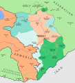
Attēls:2020 Nagorno-Karabakh ceasefire map.svg

Size of this PNG preview of this SVG file: 544 × 599 pikseļi. Citi izmēri: 218 × 240 pikseļi | 436 × 480 pikseļi | 697 × 768 pikseļi | 930 × 1 024 pikseļi | 1 859 × 2 048 pikseļi | 1 292 × 1 423 pikseļi.
Sākotnējais fails (SVG fails, definētais izmērs 1 292 × 1 423 pikseļi, faila izmērs: 1,36 MB)
Faila hronoloģija
Uzklikšķini uz datums/laiks kolonnā esošās saites, lai apskatītos, kā šis fails izskatījās tad.
| Datums/Laiks | Attēls | Izmēri | Dalībnieks | Komentārs | |
|---|---|---|---|---|---|
| tagadējais | 2022. gada 12. augusts, plkst. 19.35 |  | 1 292 × 1 423 (1,36 MB) | Golden | Reverted to version as of 21:06, 10 January 2022 (UTC) - Ceasefire agreement mentions a transport route. The line in the map makes no implication of a corridor and is vague on purpose, please don't take your enwiki edit warrings to Commons |
| 2022. gada 12. augusts, plkst. 14.11 |  | 1 292 × 1 423 (1,35 MB) | Kevo327 | removed OR corridor arrow, WP:CRYSTAL also applies | |
| 2022. gada 11. janvāris, plkst. 00.06 |  | 1 292 × 1 423 (1,36 MB) | Golden | 2 spelling fixes (Shakhbuz -> Shahbuz; Gubadli -> Gubadly) | |
| 2021. gada 4. decembris, plkst. 23.20 |  | 1 292 × 1 423 (1,35 MB) | Golden | rv, this hill is the only geolocated one; this was discussed in the discussion page, go there before making such change again please | |
| 2021. gada 4. decembris, plkst. 20.25 |  | 1 292 × 1 423 (1,36 MB) | Taron Saharyan | Reverted to version as of 16:25, 10 February 2021 (UTC) perhaps under Azerbaijani control one height on this line, this is not indicated on the map proportionately | |
| 2021. gada 12. februāris, plkst. 20.31 |  | 1 292 × 1 423 (1,35 MB) | Mapeh | Reverted to version as of 10:26, 31 January 2021 (UTC) (as per talk page) | |
| 2021. gada 10. februāris, plkst. 19.25 |  | 1 292 × 1 423 (1,36 MB) | Mr,p balçi | Reverted to version as of 19:27, 20 January 2021 (UTC) . Edit for Murovdag Area BBC Russian Map (5 November): (https://www.bbc.com/russian/live/news-54686682/page/2) BBC News Map (27 October) : (https://www.bbc.com/news/world-europe-54862180) | |
| 2021. gada 31. janvāris, plkst. 13.26 |  | 1 292 × 1 423 (1,35 MB) | Mapeh | Corrected mountain zone conquered by Azerbaijan in the North as per talk page. | |
| 2021. gada 20. janvāris, plkst. 22.27 |  | 1 292 × 1 423 (1,36 MB) | Mapeh | Changed Azeri name of Dadivank/Vang. | |
| 2021. gada 20. janvāris, plkst. 14.16 |  | 1 292 × 1 423 (1,36 MB) | Mapeh | Added Dadivank/Khutavank Russian military zone |
Faila lietojums
Šo failu izmanto šajā 1 lapā:
Globālais faila lietojums
Šīs Vikipēdijas izmanto šo failu:
- Izmantojums af.wikipedia.org
- Izmantojums als.wikipedia.org
- Izmantojums ar.wikipedia.org
- Izmantojums azb.wikipedia.org
- Izmantojums az.wikipedia.org
- Izmantojums bn.wikipedia.org
- Izmantojums ca.wikipedia.org
- Izmantojums de.wikipedia.org
- Izmantojums el.wikipedia.org
- Izmantojums en.wikipedia.org
- Political status of Nagorno-Karabakh
- List of cities and towns in Artsakh
- User:AntonSamuel/sandbox
- User:Falcaorib
- Second Nagorno-Karabakh War
- 2020 Nagorno-Karabakh ceasefire agreement
- Talk:2020 Nagorno-Karabakh ceasefire agreement
- Talk:Second Nagorno-Karabakh War/Archive 16
- Zangezur corridor
- Talk:Armenia/Archive 9
- Wikipedia:Wikipedia Signpost/2021-12-28/Deletion report
- Wikipedia:Wikipedia Signpost/Single/2021-12-28
- Izmantojums en.wikivoyage.org
- Izmantojums eo.wikipedia.org
- Izmantojums es.wikipedia.org
- Izmantojums fa.wikipedia.org
- Izmantojums fi.wikipedia.org
- Izmantojums fr.wikipedia.org
- Izmantojums he.wikipedia.org
- Izmantojums hr.wikipedia.org
- Izmantojums hy.wikipedia.org
Skatīt šī faila pilno globālo izmantojumu.