Attēls:Northumbria 802.jpg

Šī priekšskata izmērs: 486 × 599 pikseļi. Citi izmēri: 195 × 240 pikseļi | 389 × 480 pikseļi | 623 × 768 pikseļi | 831 × 1 024 pikseļi | 1 800 × 2 218 pikseļi.
Sākotnējais fails (1 800 × 2 218 pikseļi, faila izmērs: 649 KB, MIME tips: image/jpeg)
| Šis fails ir no Vikikrātuves. Tā apraksts no attēla lapas Vikikrātuvē ir parādīts zemāk. Vikikrātuve ir brīvi licencēta failu krātuve. Tu vari tai palīdzēt. |
Kopsavilkums
| Apraksts |
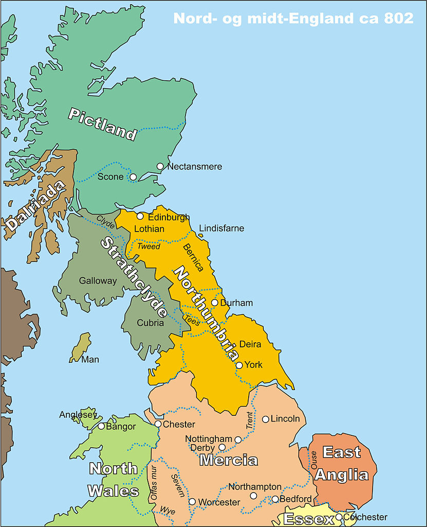
Norsk bokmål: Kart over midt- og nord-England, spesielt Northumbria, rundt år 802
English: Map of middle and northern England, centred around Northumbria, circa 802 |
| Datums | |
| Avots | My own drawing, drawn in CorelDraw12, source file available on request, or in different file formats |
| Autors | Finn (the uploader) |
| Atļauja: (Šī faila izmantošana citur) |
PD |
Licence
| I, the copyright holder of this work, release this work into the public domain. This applies worldwide. In some countries this may not be legally possible; if so: I grant anyone the right to use this work for any purpose, without any conditions, unless such conditions are required by law. |
Faila hronoloģija
Uzklikšķini uz datums/laiks kolonnā esošās saites, lai apskatītos, kā šis fails izskatījās tad.
| Datums/Laiks | Attēls | Izmēri | Dalībnieks | Komentārs | |
|---|---|---|---|---|---|
| tagadējais | 2006. gada 20. oktobris, plkst. 00.22 | | 1 800 × 2 218 (649 KB) | Finn Bjorklid | == Summary == {{Information |Description=Kart over midt- og nord-England, spesielt Northumbria, rundt år 802 (Map of Middle and Northern England, spc. Northumbria, around 802) |Source=My own drawing, drawn in CorelDraw12, source file available on request |
Faila lietojums
Šo failu izmanto šajā 1 lapā:
Globālais faila lietojums
Šīs Vikipēdijas izmanto šo failu:
- Izmantojums br.wikipedia.org
- Izmantojums da.wikipedia.org
- Izmantojums de.wikipedia.org
- Izmantojums en.wikipedia.org
- Izmantojums eo.wikipedia.org
- Izmantojums fr.wikipedia.org
- Izmantojums fr.wiktionary.org
- Izmantojums fy.wikipedia.org
- Izmantojums hr.wikipedia.org
- Izmantojums nl.wikipedia.org
- Izmantojums no.wikipedia.org
- Izmantojums pt.wikipedia.org
- Izmantojums th.wikipedia.org