Attēls:Naval Station Sangley Point aerial1 c1964.jpg

Šī priekšskata izmērs: 800 × 463 pikseļi. Citi izmēri: 320 × 185 pikseļi | 810 × 469 pikseļi.
Sākotnējais fails (810 × 469 pikseļi, faila izmērs: 248 KB, MIME tips: image/jpeg)
| Šis fails ir no Vikikrātuves. Tā apraksts no attēla lapas Vikikrātuvē ir parādīts zemāk. Vikikrātuve ir brīvi licencēta failu krātuve. Tu vari tai palīdzēt. |
Kopsavilkums
| Apraksts |
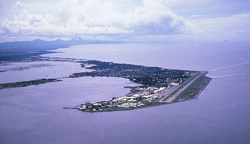
English: An aerial view of the Cavite Peninsula (circa 1963-1966) in Manila Bay, Philippines with the U.S. Naval Station Sangley Point in the foreground and Cavite City behind the base. Bacoor Bay is the body of water at the leftmost center of the picture near the mainland and Cañacao Bay is to the left of the naval base. |
| Datums | circa 1963-1966 |
| Avots | U.S. Navy Cdr. Bigley website [1] |
| Autors | Cdr. T. L. Bigley, USNR-TAR (Retired), VP-40 1963-1966 |
| Camera location | | View this and other nearby images on: OpenStreetMap |
|---|
Licence
This file is a work of a sailor or employee of the U.S. Navy, taken or made as part of that person's official duties. As a work of the U.S. federal government, it is in the public domain in the United States.
|
 | |
| This file has been identified as being free of known restrictions under copyright law, including all related and neighboring rights. | ||
Faila hronoloģija
Uzklikšķini uz datums/laiks kolonnā esošās saites, lai apskatītos, kā šis fails izskatījās tad.
| Datums/Laiks | Attēls | Izmēri | Dalībnieks | Komentārs | |
|---|---|---|---|---|---|
| tagadējais | 2010. gada 8. aprīlis, plkst. 00.28 | | 810 × 469 (248 KB) | Cobatfor | == {{int:filedesc}} == {{Information |Description=Aerial view of the U.S. Naval Station Sangley Point, Philippines, circa 1963-1966. |Source=U.S. Navy Cdr. Bigley website [http://home.earthlink.net/~patron40/] |Date={{other date|ca|1963-1966}} |Author=Cdr |
Faila lietojums
Šo failu izmanto šajā 1 lapā:
Globālais faila lietojums
Šīs Vikipēdijas izmanto šo failu:
- Izmantojums ceb.wikipedia.org
- Izmantojums en.wikipedia.org
- Izmantojums en.wikivoyage.org
- Izmantojums es.wikipedia.org
- Izmantojums ilo.wikipedia.org
- Izmantojums www.wikidata.org