Attēls:Iran-geographic map.svg

Sākotnējais fails (SVG fails, definētais izmērs 3 013 × 2 600 pikseļi, faila izmērs: 12,7 MB)
| Šis fails ir no Vikikrātuves. Tā apraksts no attēla lapas Vikikrātuvē ir parādīts zemāk. Vikikrātuve ir brīvi licencēta failu krātuve. Tu vari tai palīdzēt. |
Kopsavilkums
| Apraksts |
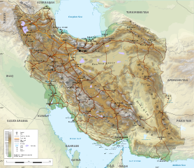
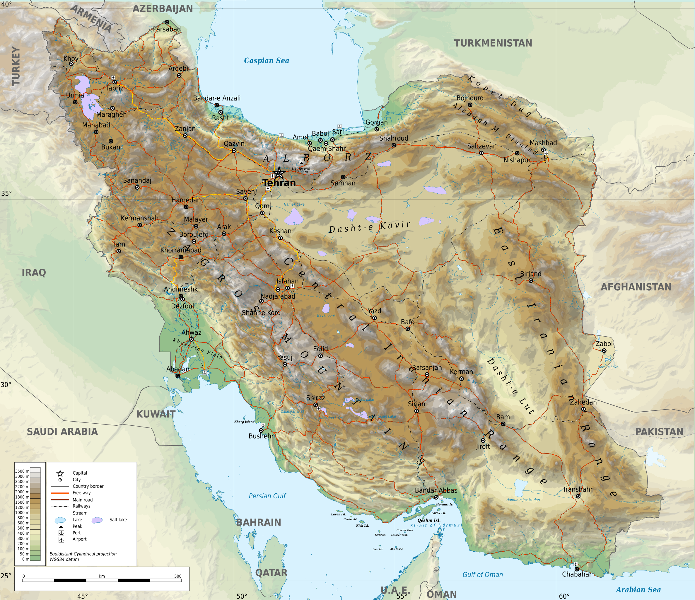
English: Geographic map of Iran. Limits of the map:
|
| Datums | |
| Avots |
Paša darbs
|
| Autors | Ikonact |
| Atļauja: (Šī faila izmantošana citur) |
Any use of this map is subject of the license(s) stated below with the condition that you credit (Wikimedia Commons user: Ikonact) as the author . A message with a reply address would also be greatly appreciated. |
| SVG veidošana |
Licence
| This work contains information from OpenStreetMap, which is made available under the Open Database License (ODbL).
The ODbL does not require any particular license for maps produced from ODbL data. Prior to 1 August 2020, map tiles produced by the OpenStreetMap Foundation were licensed under the CC-BY-SA-2.0 license. Maps produced by other people may be subject to other licences. |
- Jūs varat brīvi:
- koplietot – kopēt, izplatīt un pārraidīt darbu
- remiksēt – pielāgot darbu
- Saskaņā ar šādiem nosacījumiem:
- atsaucoties – Tev ir jānorāda autors, saite uz licenci un to, vai veiktas kādas izmaiņas. To var darīt jebkādā saprātīgā veidā, bet ne tādā, kas norādītu, ka licencētājs atbalsta tevi vai veidu, kā tu izmanto šo darbu.
- nemainot licenci – Ja tu miksē, pārveido vai izmanto materiālu, tev savs devums jāpublicē ar to pašu vai saderīgu licenci kā oriģināls.
Assessment
|
Faila hronoloģija
Uzklikšķini uz datums/laiks kolonnā esošās saites, lai apskatītos, kā šis fails izskatījās tad.
| Datums/Laiks | Attēls | Izmēri | Dalībnieks | Komentārs | |
|---|---|---|---|---|---|
| tagadējais | 2023. gada 21. septembris, plkst. 00.45 | | 3 013 × 2 600 (12,7 MB) | Socialdilema | File uploaded using svgtranslate tool (https://svgtranslate.toolforge.org/). Added translation for ca. |
| 2023. gada 20. septembris, plkst. 20.25 |  | 3 013 × 2 600 (12,69 MB) | Socialdilema | File uploaded using svgtranslate tool (https://svgtranslate.toolforge.org/). Added translation for ca. | |
| 2023. gada 20. septembris, plkst. 20.22 |  | 3 013 × 2 600 (12,68 MB) | Socialdilema | File uploaded using svgtranslate tool (https://svgtranslate.toolforge.org/). Added translation for ca. | |
| 2020. gada 8. maijs, plkst. 17.08 |  | 3 013 × 2 600 (12,62 MB) | Yamaha5 | File uploaded using svgtranslate tool (https://tools.wmflabs.org/svgtranslate/). Added translation for fa. | |
| 2020. gada 1. maijs, plkst. 23.44 |  | 3 013 × 2 600 (12,62 MB) | Ikonact | + hidden Text: MW workaround for displaying translations | |
| 2020. gada 1. maijs, plkst. 23.43 |  | 3 013 × 2 600 (12,62 MB) | Ikonact | + hidden Text: MW workaround for displaying translations | |
| 2020. gada 1. maijs, plkst. 23.39 |  | 3 013 × 2 600 (12,62 MB) | Ikonact | File uploaded using svgtranslate tool (https://tools.wmflabs.org/svgtranslate/). Added translation for bg. | |
| 2020. gada 1. maijs, plkst. 23.01 |  | 3 013 × 2 600 (12,55 MB) | Ikonact | + hidden Text: MW workaround for displaying translations | |
| 2020. gada 1. maijs, plkst. 00.49 |  | 3 013 × 2 600 (12,55 MB) | Ahmad252 | File uploaded using svgtranslate tool (https://tools.wmflabs.org/svgtranslate/). Added translation for fa. | |
| 2020. gada 1. maijs, plkst. 00.10 |  | 3 013 × 2 600 (13,24 MB) | Ikonact | + legend |
Faila lietojums
Šo failu izmanto šajā 1 lapā:
Globālais faila lietojums
Šīs Vikipēdijas izmanto šo failu:
- Izmantojums ar.wikipedia.org
- Izmantojums ast.wikipedia.org
- Izmantojums avk.wikipedia.org
- Izmantojums az.wikipedia.org
- Izmantojums bg.wikipedia.org
- Izmantojums bn.wikipedia.org
- Izmantojums ca.wikipedia.org
- Izmantojums ckb.wikipedia.org
- Izmantojums cs.wikipedia.org
- Izmantojums da.wikipedia.org
- Izmantojums diq.wikipedia.org
- Izmantojums el.wikipedia.org
- Izmantojums en.wikipedia.org
- Izmantojums eo.wikipedia.org
- Izmantojums eu.wikipedia.org
- Izmantojums fa.wikipedia.org
- جغرافیای ایران
- کاربر:Alieseraj
- توپوگرافی
- کاربر:مام وطن
- کاربر:Basp1
- کاربر:جعبه کاربر/مدافع خاک ایران
- کاربر:Gshahali
- بحث کاربر:Zzvf
- کاربر:Hamid Hassani
- کاربر:Derakhshan
- کاربر:Wiki center
- ویکیپدیا:گزیدن نگاره برگزیده/مه-۲۰۲۰
- کاربر:Arian.ramin
- ویکیپدیا:قهوهخانه/فنی/بایگانی ۶۵
- ویکیپدیا:گزیدن نگاره برگزیده/Iran-geographic map.svg
- کاربر:Adel2020
- ویکیپدیا:نگاره روز/اوت ۲۰۲۲
- کاربر:Amdanesh
- کاربر:Adolfzl64
Skatīt šī faila pilno globālo izmantojumu.