Attēls:Herrera y Tordesillas Descripcion de las Yndias Ocidentales 1601 UTA.jpg

Šī priekšskata izmērs: 800 × 600 pikseļi. Citi izmēri: 320 × 240 pikseļi | 640 × 480 pikseļi | 1 024 × 768 pikseļi | 1 280 × 960 pikseļi | 2 560 × 1 919 pikseļi | 4 362 × 3 270 pikseļi.
Sākotnējais fails (4 362 × 3 270 pikseļi, faila izmērs: 5,55 MB, MIME tips: image/jpeg)
| Šis fails ir no Vikikrātuves. Tā apraksts no attēla lapas Vikikrātuvē ir parādīts zemāk. Vikikrātuve ir brīvi licencēta failu krātuve. Tu vari tai palīdzēt. |
Kopsavilkums
| Nosaukums |
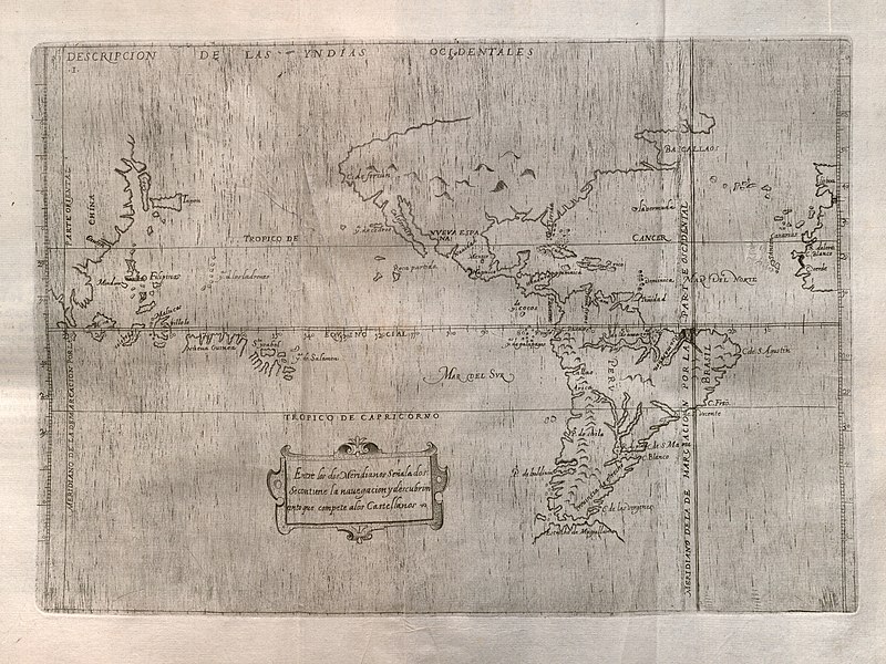
Español: Descripcion de las Yndias Ocidentales |
||||||||||||||||||||||||||
| Apraksts |
English: Spain's official history of the discovery, conquest, and colonization of the Indies at the end of the sixteenth century includes maps of which this is the first, covering the western portions of the Iberian Peninsula and Africa, the Atlantic, both the Americas, the Pacific Ocean, and the eastern portion of Asia. Prominent at right in the map is the meridian line dividing Portuguese and Spanish possessions according to the 1494 Treaty of Tordesillas. The map is largely based upon manuscript charts by Juan Lopez de Velasco, created between ca. 1575-1580. By this time the Spanish had obviously accumulated considerable geographic knowledge along with their extensive claims to a large portion of the world. The outlines of the continents, islands, and various other geographical features are remarkably accurate for their time. |
||||||||||||||||||||||||||
| Datums | |||||||||||||||||||||||||||
| Avots | UTA Libraries Cartographic Connections: ģeogrāfiskā karte / text | ||||||||||||||||||||||||||
| Izveidotājs |
|
||||||||||||||||||||||||||
| Credit line |
English: The University of Texas at Arlington Libraries Special Collections |
||||||||||||||||||||||||||
| Georeferencing | If inappropriate please set warp_status = skip to hide. | ||||||||||||||||||||||||||
| Bibliographic data | |||||||||||||||||||||||||||
| Publikācija |
Historia General de los Hechos de los Castellanos en las Islas i Tierra Firme del Mar Oceano |
||||||||||||||||||||||||||
| Autors |
|
||||||||||||||||||||||||||
| Sējums | 2 | ||||||||||||||||||||||||||
| Izdošanas vieta | Madride | ||||||||||||||||||||||||||
| Izdevējs | |||||||||||||||||||||||||||
| Archival data | |||||||||||||||||||||||||||
| Kolekcija |
|
||||||||||||||||||||||||||
| Izmēri | augstums: 22,5 cm; platums: 32 cm | ||||||||||||||||||||||||||
| Medium | engraving on paper | ||||||||||||||||||||||||||
| artwork-references | Burden, Philip D. (1996. gada) The Mapping of North America: A List of Printed Maps 1511-1670, Herts, England: Raleigh Publications, nr. 140 , p. 169 | ||||||||||||||||||||||||||

Licence

|
This file was provided to Wikimedia Commons by the University of Texas at Arlington Libraries as part of a cooperation project. The University of Texas at Arlington Libraries is part of the University of Texas at Arlington, a public research university located in Arlington, Texas.
|
|
The author died in 1626, so this work is in the public domain in its country of origin and other countries and areas where the copyright term is the author's life plus 100 years or fewer. Šis attēls ir publiskā lietošanā ASV teritorijā saskaņā ar ASV likumiem un normatīvajiem aktiem, jo ir pirmo reizi publicēts pirms 1929. gada 1. janvāra, vai ir publiskā lietošanā saskaņā ar citām juridiskām prasībām.. | |
| This file has been identified as being free of known restrictions under copyright law, including all related and neighboring rights. | |
Faila hronoloģija
Uzklikšķini uz datums/laiks kolonnā esošās saites, lai apskatītos, kā šis fails izskatījās tad.
| Datums/Laiks | Attēls | Izmēri | Dalībnieks | Komentārs | |
|---|---|---|---|---|---|
| tagadējais | 2019. gada 23. maijs, plkst. 16.28 | | 4 362 × 3 270 (5,55 MB) | Michael Barera | == {{int:filedesc}} == {{Map |title = ''Descripcion de las Yndias Ocidentales'' |description = {{en|Spain's official history of the discovery, conquest, and colonization of the Indies at the end of the sixteenth century includes maps of which this is the first, covering the western portions of the Iberian Peninsula and Africa, the Atlantic, both the Americas, the Pacific Ocean, and the eastern portion of Asia. Prominent at right in the map is the meridian line dividing Por... |
Faila lietojums
Šo failu izmanto šajā 1 lapā:
Globālais faila lietojums
Šīs Vikipēdijas izmanto šo failu:
- Izmantojums en.wikipedia.org
- Izmantojums es.wikipedia.org