Attēls:Hall Islands Landsat.jpg

Šī priekšskata izmērs: 800 × 449 pikseļi. Citi izmēri: 320 × 179 pikseļi | 640 × 359 pikseļi | 1 200 × 673 pikseļi.
Sākotnējais fails (1 200 × 673 pikseļi, faila izmērs: 140 KB, MIME tips: image/jpeg)
| Šis fails ir no Vikikrātuves. Tā apraksts no attēla lapas Vikikrātuvē ir parādīts zemāk. Vikikrātuve ir brīvi licencēta failu krātuve. Tu vari tai palīdzēt. |
Kopsavilkums
| Apraksts |
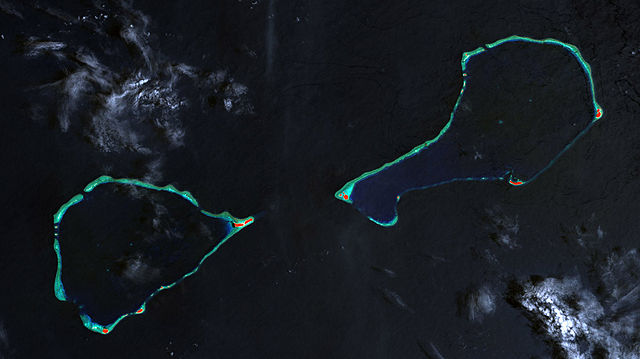
Deutsch: Landsat-7-Bild der Hall-Inseln, bestehend aus den Atollen Nomwin (links) und Murilo (rechts), Staat Chuuk, Föderierte Staaten von Mikronesien
English: Landsat 7 image of Hall Islands which consist of the two atolls Nowin (left) and Murilo (right), Chuuk State, Federated States of Micronesia |
| Datums | |
| Avots | http://www.oceandots.com/pacific/caroline/murilo3.php |
| Autors | NASA millenium coral reefs landsat archive |
Licence
| This file is in the public domain in the United States because it was solely created by NASA. NASA copyright policy states that "NASA material is not protected by copyright unless noted". (See Template:PD-USGov, NASA copyright policy page or JPL Image Use Policy.) | ||
 |
Warnings:
|
| Annotations | This image is annotated: View the annotations at Commons |
Faila hronoloģija
Uzklikšķini uz datums/laiks kolonnā esošās saites, lai apskatītos, kā šis fails izskatījās tad.
| Datums/Laiks | Attēls | Izmēri | Dalībnieks | Komentārs | |
|---|---|---|---|---|---|
| tagadējais | 2010. gada 30. janvāris, plkst. 22.36 | | 1 200 × 673 (140 KB) | Telim tor | == {{int:filedesc}} == {{Information |Description= {{de|Landsat-7-Bild der Hall-Inseln, bestehend aus den Atollen Nomwin (links) und Murilo (rechts), Staat Chuuk, Föderierte Staaten von Mikronesien}} {{en|Landsat 7 image of Hall Islands which consist of |
Faila lietojums
Šo failu izmanto šajā 1 lapā:
Globālais faila lietojums
Šīs Vikipēdijas izmanto šo failu:
- Izmantojums de.wikipedia.org
- Izmantojums en.wikipedia.org
- Izmantojums es.wikipedia.org
- Izmantojums fa.wikipedia.org
- Izmantojums fr.wikipedia.org
- Izmantojums ja.wikipedia.org
- Izmantojums mk.wikipedia.org
- Izmantojums tr.wikipedia.org
- Izmantojums www.wikidata.org
- Izmantojums zh.wikipedia.org