Attēls:Eyjafjallajökull.jpeg

Šī priekšskata izmērs: 800 × 536 pikseļi. Citi izmēri: 320 × 214 pikseļi | 640 × 429 pikseļi | 1 024 × 686 pikseļi | 1 280 × 858 pikseļi | 2 960 × 1 983 pikseļi.
Sākotnējais fails (2 960 × 1 983 pikseļi, faila izmērs: 3,96 MB, MIME tips: image/jpeg)
| Šis fails ir no Vikikrātuves. Tā apraksts no attēla lapas Vikikrātuvē ir parādīts zemāk. Vikikrātuve ir brīvi licencēta failu krātuve. Tu vari tai palīdzēt. |
| Apraksts |
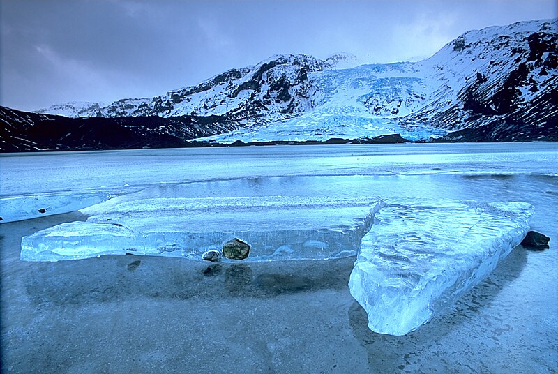
English: Gígjökull, an outlet glacier extending from Eyjafjallajökull, Iceland. Lónið is the lake visible in the foreground.
Tiếng Việt: Sông băng Eyjafjallajökull tại Iceland.
Photo was taken using the following technique:
|
||
| Datums | 2003-02-13, 11:00–12:00 | ||
| Avots |
Paša darbs: http://fam-tille.de/sparetime.html |
||
| Autors | Andreas Tille | ||
| Atļauja: (Šī faila izmantošana citur) |
Quote of http://fam-tille.de/island/winter/0213/2003_093.html - Permission is granted to copy, distribute and/or modify this images under the terms of the GNU Free Documentation License, Version 1.1 or any later version published by the Free Software Foundation. Es, šī darba autortiesību īpašnieks, publicēju to saskaņā ar šīm licencēm:
This file is licensed under the Creative Commons Attribution-Share Alike 3.0 Unported, 2.5 Generic, 2.0 Generic and 1.0 Generic license.
Jūs varat izvēlēties licenci pēc jūsu vēlmes. |

| Camera location | | View this and other nearby images on: OpenStreetMap |
|---|
| Annotations | This image is annotated: View the annotations at Commons |
Assessment
|
This image was selected as picture of the day on Wikimedia Commons for 21 December 2004. It was captioned as follows: Other languages:
Esperanto: Glaciejo Eyjafjallajökull en Islando |
This image was selected as picture of the day on Vietnamese Wikipedia.
|
Faila hronoloģija
Uzklikšķini uz datums/laiks kolonnā esošās saites, lai apskatītos, kā šis fails izskatījās tad.
| Datums/Laiks | Attēls | Izmēri | Dalībnieks | Komentārs | |
|---|---|---|---|---|---|
| tagadējais | 2004. gada 2. decembris, plkst. 15.01 | | 2 960 × 1 983 (3,96 MB) | Ævar Arnfjörð Bjarmason |
Faila lietojums
Šo failu izmanto šajā 1 lapā:
Globālais faila lietojums
Šīs Vikipēdijas izmanto šo failu:
- Izmantojums af.wikipedia.org
- Izmantojums an.wikipedia.org
- Izmantojums arc.wikipedia.org
- Izmantojums ar.wikipedia.org
- Izmantojums arz.wikipedia.org
- Izmantojums azb.wikipedia.org
- Izmantojums be.wikipedia.org
- Izmantojums bg.wikipedia.org
- Izmantojums bg.wikinews.org
- Izmantojums bo.wikipedia.org
- Izmantojums br.wikipedia.org
- Izmantojums bs.wikipedia.org
- Izmantojums ca.wikipedia.org
- Izmantojums co.wikipedia.org
- Izmantojums cs.wikipedia.org
- Izmantojums da.wikipedia.org
- Izmantojums de.wikipedia.org
- Eisscholle
- Benutzer:Rainbowfish/Test10
- Wikipedia:Kandidaten für exzellente Bilder/Archiv2005/7
- Wikipedia:Archiv/Hilfe:MediaWiki/Versionen
- Benutzer:Torinberl/Testterrain
- Benutzer:Torinberl/Benutzerseite
- Portal Diskussion:Island/Bild des Monats
- Benutzer Diskussion:Placebo111
- Portal Diskussion:Island/Bild des Monats/Archiv/2006
- Benutzer:Rainbowfish/Bilder
- Benutzer:Rainbowfish/ALT
- Portal Diskussion:Vulkane/Vulkanbild der Woche
- Izmantojums de.wiktionary.org
- Izmantojums dsb.wikipedia.org
- Izmantojums el.wikipedia.org
- Izmantojums en.wikipedia.org
Skatīt šī faila pilno globālo izmantojumu.