Attēls:Cyprus 1973 ethnic neutral.svg

Size of this PNG preview of this SVG file: 800 × 570 pikseļi. Citi izmēri: 320 × 228 pikseļi | 640 × 456 pikseļi | 1 024 × 729 pikseļi | 1 280 × 912 pikseļi | 2 560 × 1 824 pikseļi | 1 088 × 775 pikseļi.
Sākotnējais fails (SVG fails, definētais izmērs 1 088 × 775 pikseļi, faila izmērs: 76 KB)
| Šis fails ir no Vikikrātuves. Tā apraksts no attēla lapas Vikikrātuvē ir parādīts zemāk. Vikikrātuve ir brīvi licencēta failu krātuve. Tu vari tai palīdzēt. |
Kopsavilkums

This W3C-unspecified vector image was created with Inkscape .
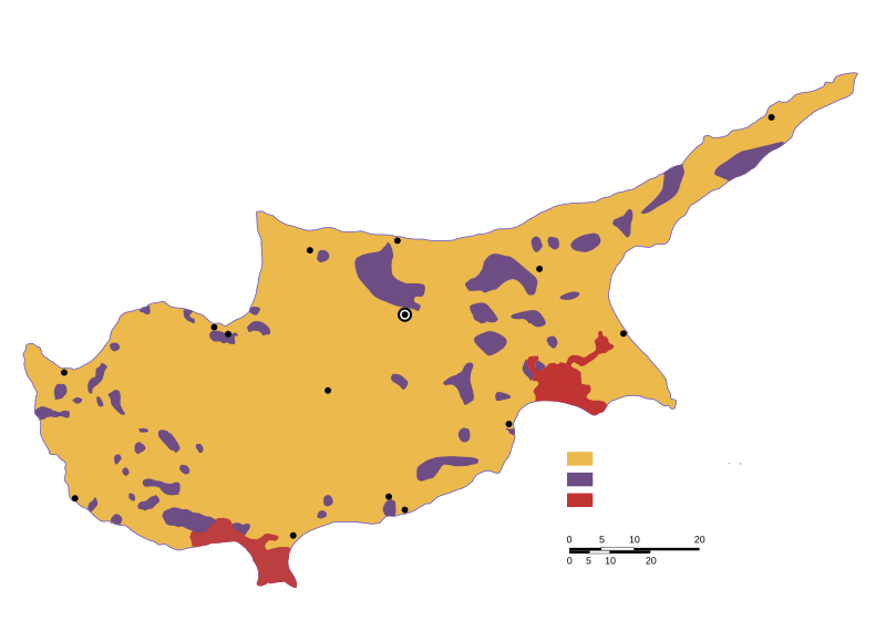
| Apraksts | Ethnic distribution svg map of Cyprus in 1973, language neutral (check the source for town names and legend). |
| Datums | |
| Avots | Drawn by a map from the "Issues of the Middle East", CIA publication, at the Perry Castaneda colletion, Link: [1]. The yellow colour shows land with predominantly greek-cypriot population, while purple shows predominantly turkish-cypriot population (known in greece as "turkish-cypriot pockets"). British military bases are displayed in red colour. |
| Autors | Badseed |
| Atļauja: (Šī faila izmantošana citur) |
Public Domain |
| Citas versijas |
|


![[1]](http://www.lib.utexas.edu/maps/europe/cyprus_ethnic_1973.jpg)
Licence
| I, the copyright holder of this work, release this work into the public domain. This applies worldwide. In some countries this may not be legally possible; if so: I grant anyone the right to use this work for any purpose, without any conditions, unless such conditions are required by law. |
Faila hronoloģija
Uzklikšķini uz datums/laiks kolonnā esošās saites, lai apskatītos, kā šis fails izskatījās tad.
| Datums/Laiks | Attēls | Izmēri | Dalībnieks | Komentārs | |
|---|---|---|---|---|---|
| tagadējais | 2007. gada 6. februāris, plkst. 23.31 | | 1 088 × 775 (76 KB) | Badseed | {{Information |Description=Ethnic distribution map of Cyprus in 1973. Labels in Greek. |Source=Drawn by a map from the "Issues of the Middle East", CIA publication, at the Perry Castaneda colletion, Link: [http://www.lib.utexas.edu/maps/europe/cyprus_eth |
Faila lietojums
Šo failu izmanto šajā 1 lapā:
Globālais faila lietojums
Šīs Vikipēdijas izmanto šo failu:
- Izmantojums am.wikipedia.org
- Izmantojums ar.wikipedia.org
- Izmantojums azb.wikipedia.org
- Izmantojums az.wikipedia.org
- Izmantojums be.wikipedia.org
- Izmantojums bg.wikipedia.org
- Izmantojums ca.wikipedia.org
- Izmantojums cs.wikipedia.org
- Izmantojums en.wikipedia.org
- Izmantojums eo.wikipedia.org
- Izmantojums es.wikipedia.org
- Izmantojums et.wikipedia.org
- Izmantojums eu.wikipedia.org
- Izmantojums fa.wikipedia.org
- Izmantojums fi.wikipedia.org
- Izmantojums fr.wikipedia.org
- Izmantojums gl.wikipedia.org
- Izmantojums hu.wikipedia.org
- Izmantojums id.wikipedia.org
- Izmantojums it.wikipedia.org
- Izmantojums ja.wikipedia.org
- Izmantojums ka.wikipedia.org
- Izmantojums nl.wikipedia.org
- Izmantojums no.wikipedia.org
- Izmantojums pnb.wikipedia.org
- Izmantojums pt.wikipedia.org
- Izmantojums ru.wikipedia.org
- Izmantojums sr.wikipedia.org
- Izmantojums sv.wikipedia.org
- Izmantojums th.wikipedia.org
- Izmantojums tr.wikipedia.org
- Izmantojums tt.wikipedia.org
- Izmantojums ur.wikipedia.org
- Izmantojums uz.wikipedia.org
- Izmantojums vi.wikipedia.org
- Izmantojums www.wikidata.org
- Izmantojums zh.wikipedia.org